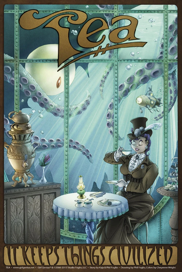
Not quite like the one in this world. For one thing, it's mostly underwater.
A possible glimpse into underwater London, also known as the Glass City.
It still manages to maintain a political presence, though. Britain's Queen, Albia, is theorized to be a powerful Spark and is referred to as "Her Undying Majesty". As long as she rules, "England is closed to Klaus"[1]. Whether this indicates hostility between the two rulers or simply a tense understanding between the two is unknown. At any rate, Albia's people find it necessary to send someone to spy on the Baron. And while Gil apparently sees nothing wrong with threatening to turn England to slag if he must[2], Dr. Sun does have a problem with it and thinks Klaus would too.[3]
Characters from England
Real and living
Living-impaired
Possibly reality-impaired
The Glass City

The badge of Albia perhaps, or just a branch of the secret service.
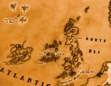
The map hints that London is submerged and known as the 'Glass City. This is also the possible residence of Queen Albia of England, and possibly the city that Ardsley Wooster once called home. Perhaps he still does. A house Badge as worn by Trelawney and Ardsley features the Union Flag and may represent Albia's house sigil.
Questions and Theories
- Why is "Her Undying Majesty" undying?
- Just how sunken is Britain, anyway?
- Who was that ill-advised Spark, and how did he do it?
- "Undying Majesty" seems to be a bit of a pun as well: Britain is mostly submerged. "Undine" is the name of a water nymph from German mythology. So you have an extremely powerful Spark who rules an underwater realm and is apparently immortal (or at least long-lived) called, "Her Undying Majesty".
- Did she try to kill Klaus, and what did he do that time?
Observations on the Map
At least it's a glimpse
"What happened to Britain?" is a popular question to discuss. Using these maps, we can see that whatever that unknown Spark did, it was even more drastic than our world's global warming. Britain, from John O'Groats to the Isles of Scilly to the Cliffs of Dover sank well over 14 meters overall, possibly more than double that. Herein is an attempt to describe the devastation, comparing the Wulfenbach map to that of the American National Geographic Society[4]:
The Home Counties are, for the most part, submerged.
The first dry land reached travelling away from the Glass City would be the Isle of Oxfordshire. It appears to extend SW as far as Swindon, and NE all the way into south Lincolnshire, but not quite including (possibly) the ancient city of Leicester. It appears to include most of Northamptonshire. A fairly narrow island, it vaguely resembles the main body of Japan.
Immediately to the south of Oxfordshire is a more compact island with an indiscernable feature, either a mountain or a large lake/small inland sea. Let's call this the Isle of Salisbury, because it naturally does not include the sunken port of Southampton, and does not extend to the Severn mouth cities. The westernmost point seems to be around Yeovil.
Next westerly is the Isle of Devon, from the peninsula's northern coastline in a vaguely round section which excludes Plymouth but seems to include Torquay and, with a swerve away from the coast we're used to, Honiton.
Last along this line of travel is the Isle of Cornwall, narrow and extending from roughly Bodmin (NE) to Truro (SW), centred between the modern coastlines.
Returning to our reference point of Oxford, we head NW to Wales, largely intact due to its springback from glacial weight and mountainous territorry. The Isle of Mon (Anglesey) and the Gwynnedd coast are submerged, as is most of Dyfed (Pembrokeshire, southern Carmarthenshire), and the areas of Monmouth and Glamorgan around the Severn Estuary again. There appears to be a large embayment to the east of the Brecon Beacons, up to around the famous booktown of Hay-on-Wye.
Northeast of Oxford, along that island's long axis, is a small island which appears to have Grimsby on its northern shore. Directly north of it, and separated by almost the same distance as it is from Oxford are two more smallish islands, one comprising the most of The Wolds, the next north including Scarborough and the bulk of the Cleveland Hills.
The island comprising the greatest bulk of dry British land looks rather like an arm extending from the north, its fisted hand crooking a finger at Oxford. Edinburgh is at the northernmost shore of this mighty island; the Isle of the Cleveland Hills is tucked into a fold in its sleeve just northeast of the "wrist".
The "hand" seems to include the areas of Birmingham/Coventry (at least in part), Derby, Nottingham and Leicester. It goes north to include possibly Manchester and Blackpool - the western coast is partially intact - and definitely Leeds and York. The coastline which has Barrow-in-Furness at its point is drowned, but the northern two-thirds of Cumbria is intact up to the expanded Firth, but then they are mountains.
At a line roughly level with Newcastle upon Tyne, the modern width of Britain is identical to Drowned Britain's, if for just a short distance. North of the Newcastle area, the eastern coast dips in and out irregularly until Berwick-upon-Tweed. It then curves north to create the northern coastline, which possibly includes part of Glasgow.
North of the Isle of the Midlands, the Isle of the Nearer Highlands is largely intact, although Dundee, Perth and Aberdeen have drowned, as have some of the western islands off the southern coast.
The Isle of the Farther Highlands, split off by the deepening and complete flooding of the Great Glen, is also much like on modern maps, except for the flooding of a stretch of coastland which had Wick at its northeastern end. The Shetlands and Orkneys appear to have been unaffected. The Isle of Lewis, the Harrises and the Uists are gone along with Skye.
The Isle of Man has sunk, and the Irelands comprise sixteen major islands, not annotated here.
At the spot where modern London would be, apparently underwater, is a point listed as "Glass City". This appears to be in an area listed as "England Deep".
Iceland seems to be gone; in that location there are a tiny pair of islands listed as "The Island of Gold", with several signposts indicating "Perfectly Safe" and "No Monsters Here!" (One might presume some sarcasm by the map writer).